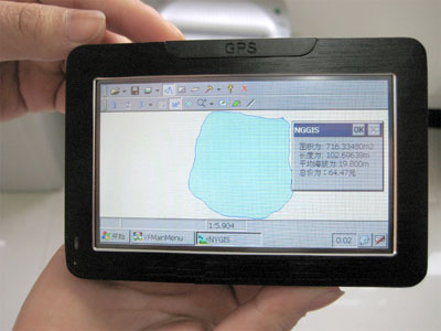
Zhejiang Top Instrument Co., Ltd.'s latest TMJ-2009 area meter has a perfect combination of high-precision GPS positioning system, accurate area calculation method and intelligent handheld computer system, realizing any irregular area of ​​real-time testing, dynamic graphic display and Data intelligence processing and storage. A measurement can be obtained at the same time measurement area, perimeter, distance, slope and other data. The measured area graph and all measurement data can be recalled at any time for easy file retention. In addition to the measurement area, it is also a powerful car navigation device with entertainment functions. It has audio playback, movie playback, games and other functions, but because the original customers are used to the old TMJ-1 type area measuring instrument, In the process of using, there will be questions raised by users. I will summarize here:
Do you think the measurement is inaccurate? There are several reasons that cause these obstacles to be eliminated and the accuracy is high.
1. Satellite interference occurred in the measured position. Such as China Mobile and other towers;
2. In the case of large-scale buildings and other disturbances in the measured position, the area meter receives satellites, resulting in poor signals and inaccurate positioning;
3. Reduce the walking speed at the corner during the measurement so that the area meter has enough time to locate the turning point.
Some faults are not the problems of the instrument itself, but are the problems that are used. Here are some of the troubleshooting of the area meter during use:
1, how can I not open the machine?
This is because the instrument is dead, and it can be turned on after it is fully charged.
2. Can't I open the machine after my machine is charged?
This situation occurs, it should be the instrument is still in use, suddenly no electricity, is an abnormal shutdown, with a handwritten point on the edge of a RESET hole, restart it.
3, after the test finished, point M2 after the middle of the figure, jump out of the invalid area perimeter how is it?
After this test, you can click on the screen white (outside of the graphics circle), and the point is in the middle of the blue one. This is the shape of the ground you just measured.
4, I began to measure the number 123, then how to end the viewing area after the completion of the measurement?
After the measurement is completed, the point number 12 ends the measurement.
5. How do I set the unit price per acre?
In the first column of the area meter's measurement interface, there is a gimmick icon that sets the unit price. There is a software disk in the lower right corner of the instrument screen, because the display time of the software disk is very short. After the point is opened, drag the software disk to the nearest place where it needs to be input.
6. How do I know if the machine has found a signal?
There is a GPS message on the homepage or tool of the instrument. It is possible to clearly check all satellite signal conditions at that time. The red color indicates that no signal is received; the blue color indicates that the signal is received, but it is not a stable signal; The green expression is received and is a stable signal.
7. Why did the route displayed by the machine go against me when I left?
Because the instrument's default internal display is north, south, west, right and east, the one line of the land you measured will not be a north-south direction. The same is true.
8. After I boot up, the screen shows a solid bar or bar. The software on the desktop is invisible.
This is a voltage instability, or the last shutdown is an abnormal shutdown, after the charge is still a case like this, you can click RESET to restart.
A summary of the TMJ-2009 area meter features:
1, 4.3-inch widescreen design, full Chinese color touch screen, no buttons;
2, while walking out of the graphics, measurement synchronization directly on the big screen;
3, in addition to measuring the projected area, you can also measure the slope area;
4. The recorded measurement graph can be viewed at any time, and the distance between any two points in the measurement graph can be calculated to facilitate the engineering mapping and calculation;
5, can correct the boundary, so that the measurement is more realistic, higher precision;
6, the unit price can be set directly after the settlement price;
7, polymer high-energy lithium battery (charge), battery capacity;
8. With on-board navigation function: The professional map implements the function of surveying electronic radar and TMC traffic, and brings you the latest safe traffic information;
9, entertainment functions: with MP3/MP4 audio playback, you can watch movies, FALSH animation playback, game features;

Figure TMJ-2009 GPS area measuring instrument
Water Plug,Chrome Water Plug,Stainless Steel Plug,Water Pipe Plug
KAIPING LIPU SANITARY WARE CO.LTD , https://www.ebt-pro.com